A high-end chartplotter is little more than an expensive paperweight if your vessel’s electrical backbone cannot support it. Many boaters in Durban feel understandably overwhelmed by the sheer volume of “must-have” gadgets, whilst others lose sleep over NMEA 2000 compatibility or the constant threat of saltwater corrosion. It is natural to feel hesitant when your safety at sea depends on a complex web of electronics. This guide simplifies the process of selecting and installing boat navigation systems for the 2026 season, ensuring you invest only in tools that offer genuine utility and long-term reliability.
We believe your helm should feel like a steady hand rather than a confusing distraction. By following this professional approach, you will gain a clear understanding of essential hardware versus optional extras, learn how to prevent electrical failure in our humid coastal environment, and build the confidence to make an informed purchase decision. We will cover everything from the latest S-100 standards to practical integration tips that keep your vessel sea-ready and compliant with modern maritime requirements.
Key Takeaways
- Understand why the Multi-Function Display (MFD) acts as the central hub for modern boat navigation systems and why redundancy is non-negotiable for safe offshore work.
- Learn how to match your electronics to your specific boating style, prioritising pixel density and screen resolution over sheer size for better visibility in bright coastal sunlight.
- Master the fundamentals of NMEA 2000 networking to ensure seamless communication between sensors and displays through a robust backbone architecture.
- Discover professional installation techniques that prevent electromagnetic interference and ensure your transducer provides a clear signal even at high speeds in choppy waters.
- Implement a proactive maintenance routine to protect your high-value electronics from saltwater corrosion and manage software updates without risking system stability.
Understanding Modern Boat Navigation Systems: More Than Just GPS
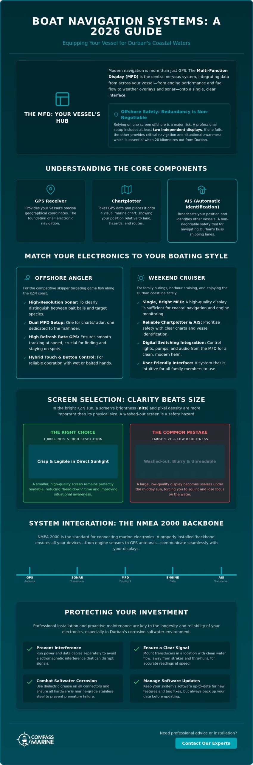
Modern boat navigation systems have evolved far beyond the simple handheld GPS units of the past. Today, the Multi-Function Display (MFD) serves as the central nervous system of your vessel. It is no longer just a screen for viewing maps; it is a sophisticated computer that synthesises data from every corner of your boat. From monitoring fuel flow in your outboards to overlaying weather patterns on your route, the MFD provides a unified interface that simplifies complex decision-making during a heavy swell off the Umgeni River mouth.
Relying on a single screen for offshore work is a risk we don’t recommend for Durban skippers. If your primary display fails whilst you are 20 kilometres out, your situational awareness vanishes instantly. A professional suite usually includes at least two independent displays. This redundancy ensures that if one unit suffers an electrical fault or physical damage, the second can take over critical functions. It also allows you to dedicate one screen to high-resolution sonar whilst the other displays your primary chart, a setup favoured by local competitive anglers targeting game fish along the coast.
The Core Components: GPS, Chartplotters, and AIS
Understanding the hierarchy of your hardware is essential before making a purchase. A GPS receiver simply provides coordinates, but what is a Chartplotter exactly? It is the device that places those coordinates onto a visual map, allowing you to see your position relative to land and hazards. In 2026, AIS (Automatic Identification System) has become a non-negotiable safety tool for navigating the busy shipping lanes outside Durban Harbour. It broadcasts your position and receives data from nearby commercial vessels, helping you avoid collisions long before they become a threat. Digital switching further enhances this by letting you control lights and pumps directly from your screen, reducing the need for physical toggle switches that often succumb to salt spray and corrosion.
The Value of Situational Awareness at Sea
The ultimate goal of modern boat navigation systems is to keep your eyes on the water. Integrated systems reduce “head-down” time by providing audible alerts and clear visual overlays of radar and sonar data. For high-speed craft, we insist on GPS antennas with high refresh rates. This ensures your position on the screen updates multiple times per second, preventing the “jumping” icon that can lead to navigation errors when entering a narrow channel. Whilst digital assistance is invaluable, it should complement, not replace, traditional seamanship and a sharp lookout.
Choosing the Right Navigation Suite for Your Boating Style
Selecting the ideal boat navigation systems begins with an honest assessment of your primary activities on the water. A skipper preparing for competitive offshore angling out of Durban requires a vastly different setup than a family enjoying weekend cruises on Midmar Dam. The environment dictates the hardware. Whilst a basic chartplotter suffices for inland waters, the unpredictable conditions of the Indian Ocean demand high-performance equipment that can handle salt spray, vibration, and intense glare.
Many boaters make the mistake of prioritising screen size over resolution. In the bright, direct sunlight of the KwaZulu-Natal coast, pixel density and nit ratings (brightness) are more important than sheer inches. A smaller, high-resolution screen with 1,000+ nits of brightness will remain legible when the sun is overhead, whereas a larger, lower-quality display will wash out, leaving you squinting at your course. Consider your helm’s physical layout too. If you frequently operate with wet or fish-slimed hands, a hybrid interface with physical buttons is superior to a pure touchscreen, which can become unresponsive when coated in moisture.
Budgeting for these systems must account for the “invisible” costs that often surprise new owners. The display unit is only part of the investment. High-quality transducers, NMEA 2000 cabling, and robust stainless steel mounting hardware can significantly increase the final tally. Cutting corners on these components often leads to signal loss or premature failure due to our high coastal humidity. If you are unsure about the electrical demands of a new suite, our team can assist with professional electrical wiring and fault diagnostics to ensure your backbone is up to the task.
Angling-Specific Requirements: Sonar and Charting
For the serious fisherman, your navigation tools must work in tandem with your fish-finding technology. Integrating high-end sonar allows you to mark specific reefs and pinnacles with pinpoint accuracy. Side-scan and down-scan imaging are particularly effective for identifying the rocky structures favoured by local game fish. If you are looking to upgrade your setup, you can read our detailed guide on choosing the best fish finder to understand how different frequencies impact your visibility at various depths.
Cruising and Safety: Radar and Autopilot Integration
If your goals involve long-range coastal passages, radar and autopilot become essential components of your boat navigation systems. Radar is your best defence when navigating the busy shipping lanes near Durban Harbour during low visibility or night-time entries. Autopilot integration not only reduces skipper fatigue on the run to Richards Bay but also improves fuel efficiency by maintaining a more precise heading than a human pilot. Ensure your chosen suite allows for these expansions and meets the necessary requirements for your Cat C safety equipment certification.
NMEA 2000 and System Integration: Making Everything Talk
The introduction of the NMEA 2000 standard revolutionised how we approach boat navigation systems. Before this protocol, connecting different devices was a frustrating task involving proprietary cables and mismatched baud rates. Today, a standardised “plug and play” network allows your chartplotter, autopilot, and engine sensors to share data seamlessly across a single cable. This integration provides skippers with a comprehensive overview of their vessel’s health and position without the clutter of multiple standalone displays at the helm.
Reliability in a digital network depends entirely on its backbone architecture. A proper NMEA 2000 network requires a central trunk line with 120-ohm terminators at each physical end to prevent signal reflection. Every device then connects to this trunk via a T-connector and a drop cable. We often see DIY installations fail because the backbone lacks these terminators or has been powered from multiple points, which leads to data corruption. A single, stable power drop is essential to maintain the 12V supply required for the network’s internal microchips to function correctly. For a deeper understanding of how to build a resilient system from the ground up, our marine electronics installation reference guide covers the full scope of 2026 best practices for wiring, integration, and environmental protection.
A common question from Durban boaters is whether they can mix brands like Lowrance, Simrad, and Garmin. Whilst basic data like GPS position, depth, and wind speed are standardised across all NMEA 2000 certified devices, proprietary features often are not. For example, you generally cannot share high-detail sonar images or control a radar unit across different brands. If you are integrating legacy NMEA 0183 equipment, such as an older but reliable VHF radio, you will need a dedicated gateway to translate the old serial data into the modern digital format.
Engine Data Integration
Modern displays allow you to visualise fuel flow, RPM, and engine temperature with far greater precision than traditional analogue gauges. Digital monitoring provides early warning signs of mechanical issues before they become catastrophic failures at sea. For complex setups involving multiple outboards or bridging older electronic engines to new displays, we recommend consulting our guide on marine technical services to ensure total system reliability and compliance.
Troubleshooting Network Conflicts
Identifying conflicts in a complex electronics suite requires a methodical approach. If your screen suddenly loses depth data or your autopilot starts hunting, it’s often a sign of a failing backbone or a data loop. In our humid coastal environment, saltwater ingress in a single T-connector can cause a voltage drop that brings down the entire network. Always check for tight connections and use a voltmeter to ensure your backbone is receiving a steady 12V supply. Common signs of failure include flickering data fields or “Device Not Found” errors on your MFD. For a structured approach to diagnosing these issues, our guide to marine electrical fault finding provides practical steps to identify and resolve the root cause before it leaves you stranded offshore.
Professional Installation: Ensuring Reliability and Longevity
A professional installation is what separates a reliable helm from a liability at sea. Whilst the hardware for modern boat navigation systems is robust, the environment in which it operates is relentlessly hostile. In Durban, where coastal humidity and salt spray are constant factors, the integrity of your installation determines the lifespan of your electronics. A “plug and play” approach rarely accounts for the nuances of marine electrical systems or the physical stresses of the Indian Ocean.
Success begins with a methodical five-step process. First, cable runs must be planned to avoid electromagnetic interference. Running sensitive sonar or radar cables alongside high-current engine looms can distort your data. Second, transducer mounting is critical. To ensure a clean signal at high speeds, the transducer must be positioned in “clean” water, away from strakes, rivets, or hull steps that cause turbulence. Third, power management requires dedicated fuse blocks. Sharing a circuit with a high-draw item like a windlass or a fridge often leads to voltage drops that crash your MFD.
The final steps focus on environmental protection and accuracy. Every connection should be sealed using marine-grade heat shrink and a dab of dielectric grease to keep moisture at bay. Finally, no installation is complete without calibration. Sea trials are essential to “swing” the electronic compass and verify that your GPS heading matches your actual movement on the water, accounting for local magnetic interference from steel fittings or speakers.
Wiring and Electrical Fault Diagnostics
A common mistake in DIY projects is the use of automotive-grade wiring. Automotive wire is made of bare copper which corrodes from the inside out when exposed to salt air. Professional installations use tinned copper wire, where each individual strand is coated to resist oxidation. Intermittent screen flickering or data loss is often a symptom of poor grounding or corroded terminals, and understanding the principles of marine electrical fault finding will help you diagnose whether the issue lies in your wiring, your connections, or the device itself. Maintaining your electrical health is as vital as professional marine engine servicing, as both systems rely on a stable power supply to keep you safe offshore.
Mounting and Ergonomics
Ergonomics play a vital role in skipper fatigue. Flush mounting provides a sleek, factory-finished look, but bracket mounting often offers better flexibility for adjusting viewing angles to combat the intense KwaZulu-Natal glare. Regardless of the style, all hardware must be secured with stainless steel fasteners and backing plates where necessary. This prevents the unit from vibrating loose when the hull is pounding through a heavy Durban chop. If you are experiencing electrical gremlins or need a clean helm layout, our team provides expert electrical wiring and fault diagnostics to ensure your suite is sea-ready.
Protecting Your Investment: Maintenance and Updates
The longevity of your boat navigation systems depends entirely on a consistent maintenance regime. Durban’s salt-laden air and high humidity levels are relentless, often causing microscopic salt crystals to form on sensitive hardware. A disciplined post-trip routine is your first line of defence. Always rinse external sensors, radar domes, and antennas with fresh, low-pressure water after every outing. Never use a high-pressure hose directly on displays or cable entries, as this can force moisture past the gaskets and into the internal circuitry.
Protecting the physical interface is equally vital. When your vessel is not in use, always fit the manufacturer-supplied sun covers. UV radiation in KwaZulu-Natal is intense enough to degrade plastic housings and damage liquid crystal displays over time. Before cleaning a screen, ensure all salt crystals have been rinsed away; wiping a dry, salty screen with a cloth acts like sandpaper, causing permanent scratches that compromise visibility in bright sunlight. Use only approved microfibre cloths and specialised marine screen cleaners to maintain the anti-reflective coatings.
Managing software updates requires a balanced approach. Whilst it is tempting to download the latest firmware immediately, seasoned skippers often wait a few weeks to ensure the new version is stable. A software glitch during a coastal passage can be more than an inconvenience. During the off-season or long periods of inactivity, the best way to preserve your electronics is through indoor boat storage. Keeping your vessel in a temperature-controlled environment significantly reduces the risk of moisture ingress and the gradual degradation of electrical components.
Combating Saltwater Corrosion
Corrosion is a silent threat that often begins at the connectors. Periodically inspect the rear of your MFD and NMEA backbone for signs of green oxidation or “creep” corrosion. This occurs when salt air enters a plug and begins to travel down the copper wire under the insulation. Once this process starts, the wire’s resistance increases, leading to the intermittent flickering or data loss mentioned in previous sections. Applying a small amount of dielectric grease to clean pins can provide a moisture barrier that extends the life of your connections by several years.
When to Call a Professional
Identifying whether a fault is a hardware failure or a software glitch can be difficult for the average boat owner. If your system begins rebooting spontaneously or fails to recognise a transducer that was working previously, it is time for a professional diagnostic. Attempting DIY internal repairs on modern sealed units is risky and almost always voids your warranty. As an authorised agent, Compass Marine provides the technical support needed to troubleshoot complex integration issues, ensuring your boat navigation systems remain a reliable partner on the water.
Setting a Reliable Course for the 2026 Season
A well-integrated helm is the foundation of every successful voyage. We have explored how modern boat navigation systems act as the central brain of your vessel, synthesising sonar, radar, and engine data into a single, actionable view. By prioritising a robust NMEA 2000 backbone and professional marine electronics installation techniques, you ensure that your electronics remain resilient against the harsh coastal humidity and vibration of the Durban coastline. Protecting your investment through disciplined post-trip maintenance and secure storage is just as critical as the hardware you choose.
Navigating technical complexities doesn’t have to be a solitary challenge. As an Authorised Lowrance Agent with certified technical expertise, our team specialises in marine electrical diagnostics and bespoke system integration. We are here to ensure your vessel is both compliant and sea-ready for whatever the Indian Ocean presents. Book a Professional Electronics Consultation with Compass Marine today to refine your helm with confidence. We look forward to seeing you out on the water with a system you can trust implicitly.
Frequently Asked Questions
Can I use my iPad as a primary boat navigation system?
An iPad should only serve as a secondary backup rather than your primary navigation tool. Consumer tablets aren’t ruggedised for the Durban heat and often overheat when exposed to direct sunlight on an open helm. Additionally, WiFi-only models lack a true internal GPS chip, which can lead to dangerous inaccuracies once you are out of mobile network range offshore.
What is the difference between a fish finder and a chartplotter?
A fish finder uses sonar technology to visualise what is happening beneath your hull, whilst a chartplotter uses GPS data to show your position on an electronic map. In 2026, most modern boat navigation systems are sold as Multi-Function Displays (MFDs) that integrate both features into a single unit, allowing you to overlay sonar data directly onto your charts.
How do I update the maps on my marine GPS?
Most modern units are updated via a manufacturer’s mobile app or by downloading the latest chart files onto a microSD card from a computer. Because NOAA and other agencies have phased out paper charts, keeping your electronic charts current is essential for safety. Check your manufacturer’s website for seasonal updates, as many brands now operate on a subscription-based model for high-detail mapping.
Why is my GPS losing signal when I start the engine?
Signal loss during engine startup is typically a symptom of a significant voltage drop in your electrical system. When the starter motor draws high current, the voltage available to your boat navigation systems may dip below the operational threshold, causing a temporary reboot or signal loss. Installing a dedicated house battery or a voltage stabiliser is the professional solution to this common issue.
Is NMEA 2000 compatible across all brands?
NMEA 2000 is compatible across brands for standard data like depth, heading, and engine RPM. You can generally display data from a Suzuki or Yamaha outboard on a Garmin or Lowrance screen without difficulty. However, proprietary features like radar control or advanced sonar sharing are usually brand-locked and won’t work across different manufacturers’ displays.
How much power does a modern navigation system consume?
A typical 7 to 12-inch MFD consumes between 1 and 4 amps per hour depending on the screen brightness settings. In the bright KwaZulu-Natal sun, you will likely run your backlight at 100 percent, which pushes consumption to the higher end of that scale. It’s vital to ensure your vessel’s charging system and battery bank can support this load during long drifts or trolling sessions.
Do I need a separate antenna for my AIS system?
You generally need a dedicated AIS antenna for the best performance and safety. Whilst it is possible to use an AIS splitter to share your existing VHF radio antenna, this can lead to signal loss in both devices. For offshore work where situational awareness is critical, a separate, properly mounted antenna ensures you can see and be seen by commercial traffic without interference.
What is the best way to clean my MFD screen without scratching it?
Always rinse your screen with fresh, low-pressure water before touching it with a cloth to remove abrasive salt crystals. Once the salt is gone, use a clean microfibre cloth and a cleaner specifically formulated for marine electronics. Avoid using window cleaners or ammonia-based products, as these will eventually strip away the expensive anti-reflective coatings designed to combat glare.